


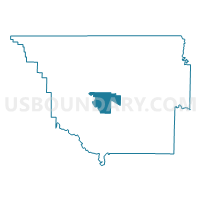
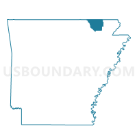
Shiloh Voting District, Randolph County, Arkansas
About
Outline

Summary
| Unique Area Identifier | 527927 |
| Name | Shiloh Voting District |
| County | Randolph County |
| State | Arkansas |
| Area (square miles) | 16.34 |
| Land Area (square miles) | 16.31 |
| Water Area (square miles) | 0.03 |
| % of Land Area | 99.85 |
| % of Water Area | 0.15 |
| Latitude of the Internal Point | 36.30414620 |
| Longtitude of the Internal Point | -91.06112020 |
Maps

Graphs
Select a template below for downloading or customizing gragh for Shiloh Voting District, Randolph County, Arkansas


Neighbors
Neighoring Voting District (by Name) Neighboring Voting District on the Map
- Demun Voting District, Randolph County, AR
- Eleven Point Voting District, Randolph County, AR
- Foster Voting District, Randolph County, AR
- Water Valley Voting District, Randolph County, AR
- West Roanoke Voting District, Randolph County, AR
Top 10 Neighboring County Subdivision (by Population) Neighboring County Subdivision on the Map
- Demun township, Randolph County, AR (8,191)
- West Roanoke township, Randolph County, AR (797)
- Shiloh township, Randolph County, AR (746)
- Foster township, Randolph County, AR (665)
- Water Valley township, Randolph County, AR (289)
- Eleven Point township, Randolph County, AR (277)
Top 10 Neighboring Unified School District (by Population) Neighboring Unified School District on the Map
- Pocahontas School District, AR (10,918)
- Twin Rivers School District, AR (3,374)
- Sloan-Hendrix School District, AR (2,972)